Tree Maps & Tree Walks
Stanford
Tree tours for your class, dorm, or department can make for a valuable and enjoyable group outing; contact us to explore possible arrangements. We also offer lectures and lead discussions on Stanford landscape history, tree diversity, and related topics.
Google map:
On phones, Google maps may work better if opened directly in your browser instead of in the Google Maps app.
| Map | Notes |
|---|---|
Stanford’s Noteworthy Trees Map (May 2024) Previous versions: |
Latest map removed Quad’s removed windmill palm and Hoover Tower’s Atlas cedar (not planted in honor of President Harrison after all); added Olmsted’s olive crescent, Eucalyptus bridgesiana grove, and alligator juniper; and re-added Monterey cypress from 2005 map. More accessible specimens chosen for gray pine and valley oak. Some tree names and descriptions updated. Trio of champion trees clearly noted. 2018 version replaced the removed Eucalyptus viminalis with E. kruseana, chose another gray pine specimen (also due to a removal), and updated entry descriptions. |
PDF maps of specific areas on campus (note dates):
| Map | Notes |
|---|---|
|
Inner Quad Map (17 Oct 2025) 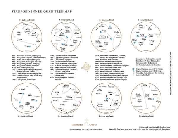
Previous versions: |
Latest map added cultivars of camellias, updated scientific names, specified a few planting years; minor changes only. Updates since publication: dove tree removed. 2024 map notes which trees still stand from the original Inner Quad planting in 1890, and which trees are featured in detailed scenes set in the Inner Quad in Richard Powers’ 2019 Pulitzer Prize winner The Overstory. Pair of Eucalyptus deglupta removed; a Brachychiton discolor added. A Butia odorata and Beaucarnea recurvata replace two original palms removed. Metrosideros changed from excelsa to kermadecensis (it may be a hybrid but more closely matches the latter). 2021 map corrects previous one (2016) as follows: Morus rubra is now M. alba. Livistona chinensis is now L. australis. Ligustrum lucidum is now Viburnum odoratissimum. |
|
NEW Outer Quad Map (Draft, 30 Jan 2026) 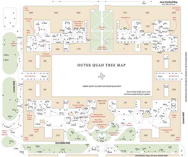
Previous versions (partial): |
Let us know what you think of this second draft, which will continue to be refined over the next few months. Its coverage overlaps with that of the 2003 Escondido Mall/South Quad Map, omitting Panama Mall in favor of including all Outer Quad courtyards. Changes compared to 2003 map (for overlapping scopes): Sculpture and court names added. Carob removed. Math Corner re-landscaped 2015: Lemon-scented gums removed, persimmon and camphor trees added. Bicolor naked coral tree added. American fringe tree added to Thomas Church Garden and elsewhere. The last remaining Blireana flowering plum is declining. |
|
NEW Law School & Canfield Court Map (5 Jan 2026) 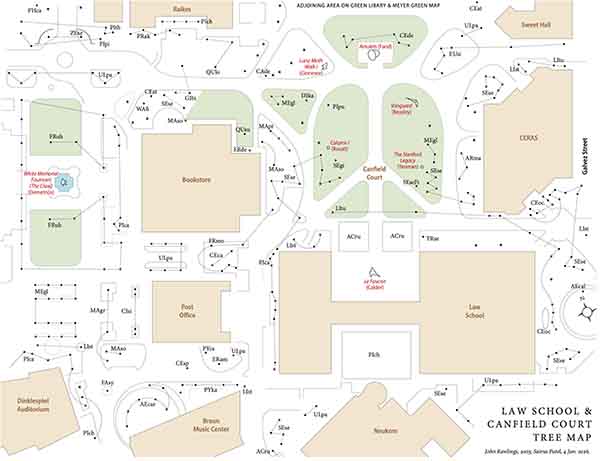
Previous versions: |
Latest map compared to 2003 map: Canfield Court’s Camperdown elm removed. Law School N. courtyard: Shamel ashes, tulip trees replaced by red maples; S. courtyard: tulip trees replaced by Chinese pistache. More Shamel ashes now surround The Claw area. Rows of dawn redwood planted in White Plaza; red horse-chestnuts at Braun; new trees south of Raikes; various other plantings. |
|
UPDATED Green Library & Meyer Green Map (4 Jan 2026) 
Previous versions: |
Latest map compared to 2022 map: New landscaping around renovated School of Education and new Raikes Building includes island oak, Engelmann oak, Freeman maple, ginkgo & flowering cherries. The beautiful Cilician fir next to the clock tower was carefully preserved. 2022 map corrects 2003 map as follows: Eucalyptus laeliae is now E. camaldulensis; Cedrus libani is now C. atlantica. Other changes: Meyer Library replaced by Meyer Green Nov 2015. Salix babylonica was removed. |
|
UPDATED Cantor Center Area Map (May 2023) 
Previous versions: |
Jan 2026 map compared to 2023 map: Trio of Akebono cherries planted on south side of the Anderson Collection. One Aleppo pine, two Desert Museum palo verde, and the ancient funeral cypress removed. 2023 map compared to 2003 map: Old Anatomy building removed. McMurtry Center and Anderson Collection built. Map area covered enlarged. Fortunately, the ancient and magnificent tree yucca (a national champion) remains. |
|
NEW Old Union Map (7 Jan 2026) 
Previous versions: |
Latest map compared to 2003 map: In 2007, Old Union’s inner courts were fully replanted, sparing only one coast live oak in the main court; Canary Island palms were introduced to the main court. Other changes at the time: the rare and lovely Erythrina humeana facing White Plaza was removed; ‘Natchez’ crape myrtle replaced the white mulberries on the southern face of the Clubhouse. In 2025 the declining California plane just south of Old Union was removed. |
Wilbur Hall Tree Map. From Trees of Stanford & Environs, Ronald Bracewell (2005); map by John Rawlings. Gleditsia triacanthos and two Brachychiton populneus in the map have since been removed.
From avocados to zelkovas: A sampler of Stanford trees. Campus Report, 14 Nov 1984, Karen Bartholomew.
Tiptoe through the Trees map. Produced by Stanford University Health Improvement Program in 1984, this is dated, but still a useful and innovative approach to campus tree appreciation.
Ron Bracewell Memorial Grove: Initial planting map (28 Feb 2008), prepared by Grounds Services. Updated map (7 Jan 2025).
Eucalypt Walk: Campus Drive between Escondido Road and Serra Street was planted as a veritable eucalypt arboretum in the 1960s. Construction in the area in 2017–2020 removed almost all of it. William Parker’s 1964–1972 map. Ron Bracewell’s 13 Oct 2000 map.
Eucalyptus Dreams field trip (part of History 53S, Feb 2007).
Stanford Grounds Services: Arizona Garden & other points of interest (SU login may be needed).
Neighboring cities
Canopy offers guided tree walks in neighborhoods in Palo Alto and surrounding communities. The maps are available online.
On Tree Walks
These maps enable one to visit and get acquainted with particular trees and learn their names. A major step on the path to familiarity is learning a name; thus armed, the explorer can look up information and talk to others about discoveries.
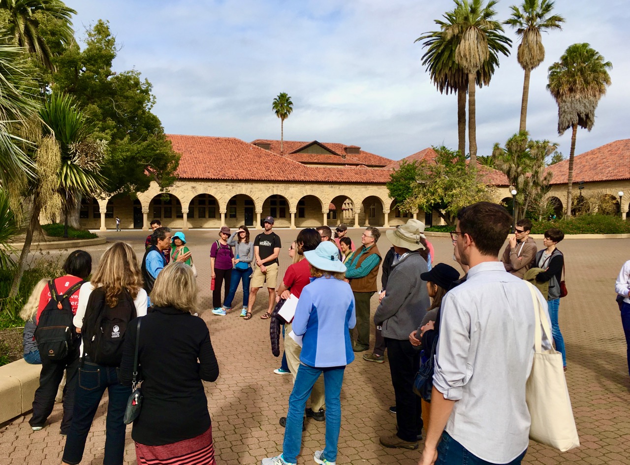
These Stanford maps, along with the Noteworthy Trees Map, can be used to create pleasant outings or guided tree walks. To be a tour guide, it is not necessary to be an expert. Experience shows that groups should be limited to about a dozen people; if there are more, you will find the laggards strolling up to a tree just as you are moving off with the main group to your next fascinating stop. Those bringing up the rear have, however, been enjoying their own conversation and don’t seem to mind missing your commentary, no matter how brilliant.
The Stanford detail maps (in PDF above) provide a good start for those planning tree tours. The areas mapped are centrally located, and have both a diversity and density of trees. Scale varies somewhat, but fixed features – buildings, pathways, streets, sculpture, and lawns – should allow fairly precise location.
Residents of neighboring cities are in the same climatic zone as Stanford and will find our tree collection relevant to their own interests. Conversely there are specimens of interest to campus dwellers that are located off campus. More than a dozen Palo Alto tree walks are available in printed form and online (see above) from Canopy, a local tree advocacy group.
- “On Tree Walks” is adapted from Trees of Stanford and Environs (2005) by Ronald Bracewell.
- The original seven campus tree map PDFs (2003) that appear in the book were created by John Rawlings, with design by Tony Gee.
- Julia Goolsby migrated the Noteworthy Trees map from its original PDF format to a Google Maps version (May 2018).

